Mexico City’s Historic Center — the Centro Historico — is one of those places that makes you rethink what a “city center” can be. We’re talking about 668 blocks, 9,000 buildings, and roughly 700 years of continuous history stacked on top of itself like a geological record you can walk through. Aztec temple foundations sit beneath colonial palaces. Art Deco towers rise next to Baroque churches. A pedestrian street that was once a silver market now hosts Starbucks and street performers doing backflips.
UNESCO gave it World Heritage status in 1987, grouping it with the floating gardens of Xochimilco under a single designation. That’s nice and all, but the real draw isn’t a plaque — it’s the fact that you can spend a full week here and still stumble onto a courtyard, museum, or taco stand you hadn’t noticed before.
This is the beating heart of a metropolitan area of 22 million people. The political center. The cultural center. The place where every major protest, celebration, and civic ritual plays out. If you only see one neighborhood in Mexico City, it should be this one.
From Aztec Island to Spanish Capital
Before there was a Centro Historico, there was Tenochtitlan — the capital of the Aztec Empire, founded around 1325 on an island in Lake Texcoco. According to legend, the Aztecs built their city on the spot where they saw an eagle perched on a nopal cactus with a serpent in its beak. That image is still on Mexico’s flag, its coins, and about a thousand other things.
Tenochtitlan was a marvel of urban planning. The city was laid out in a grid aligned to the cardinal directions, with streets and canals forming orderly blocks. It was divided into four main neighborhoods — Cuepopan, Atzacualco, Moyotla, and Zoquipan — radiating from a massive ceremonial center where the Templo Mayor stood. At its peak, the city had somewhere between 200,000 and 300,000 residents, making it one of the largest cities in the world at the time.
When Hernan Cortes and his forces conquered the city in 1521, they didn’t start from scratch. Under the supervision of Spanish city planner Alonso Garcia Bravo, the rebuild preserved much of the Aztec street grid. Many of the main thoroughfares — renamed, of course — still follow the same routes they did 500 years ago. The colonial city was literally built with the rubble of the Aztec one. Much of the tezontle stone in those grand colonial facades? It came from demolished temples.
The Spanish kept the city’s basic divisions too, just slapped Christian prefixes on them: San Juan Moyotla, Santa Maria Tlaquechiuacan, San Sebastian Atzacualco, San Pedro Teopan. That pattern of layering new identities onto old bones is the defining characteristic of the Centro. You see it everywhere.
The Zocalo: Ground Zero
Everything in the Centro Historico revolves around the Zocalo — officially called the Plaza de la Constitucion, but nobody calls it that. It’s the largest public plaza in Latin America and one of the largest in the world, capable of holding nearly 100,000 people. And it regularly does: for political rallies, concerts, Day of the Dead installations, and the annual Independence Day ceremony every September 15th.
The Zocalo sits almost exactly where the Aztec ceremonial precinct once stood. The center of the Aztec world became the center of New Spain, which became the center of modern Mexico. That’s not a metaphor — it’s literally the same piece of ground.
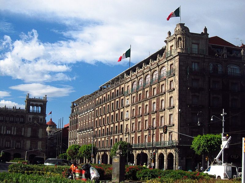
Flanking the plaza on its east side is the Palacio Nacional, which stretches the entire length of the block. It was built on the ruins of Moctezuma II’s palace using the same tezontle stone from the original Aztec structure. Today it houses the offices of the President of Mexico, the Federal Treasury, and Diego Rivera’s famous murals depicting the entire sweep of Mexican history from pre-Hispanic civilization through the Revolution. The central stairway mural alone is worth the visit.
On the north side stands the Metropolitan Cathedral, the largest and oldest cathedral in Latin America. Construction started in 1573 and wasn’t fully completed until 1813 — that’s 240 years of building, which is why you can spot Baroque, Neoclassical, and Renaissance elements all in the same structure. The cathedral sits on soft lakebed soil (as does most of the Centro) and has been slowly sinking for centuries, requiring a massive engineering project between 1989 and 2000 just to keep it standing straight.
Just northeast of the Zocalo, you’ll find the Templo Mayor archaeological site — the remains of the Aztec’s most important temple. Its location had been lost for centuries until 1978, when electrical workers accidentally uncovered an eight-ton stone disk depicting the goddess Coyolxauhqui. The subsequent excavation revealed a pyramid built in multiple layers, each one constructed on top of the previous. The adjoining museum houses thousands of artifacts and is one of the most important archaeological collections in the Americas.
Calle Madero: The Pedestrian Spine

If the Zocalo is the Centro’s heart, Calle Madero is its main artery. This 700-meter pedestrian street runs east-west from the Zocalo to the Eje Central, and it’s been one of the most important roads in Mexico City since the Spanish built it on Aztec foundations in the 1520s.
The street has had multiple names over the centuries. The western section was called “Street of San Francisco” after the monastery there. The middle stretch was “Profesa Street” after the Temple of San Felipe Neri. The eastern end was “Calle de Plateros” — Silversmiths’ Street — after the jewelry workshops that once lined it. In 1914, Pancho Villa himself renamed the whole thing after Francisco I. Madero, the revolutionary leader assassinated the year before.
Today, Madero is packed from morning to night. Street musicians, living statues, indigenous dance groups, candy vendors, and an absolute river of pedestrians. Along the way you’ll pass the Casa de los Azulejos — a colonial mansion completely covered in blue-and-white Puebla tiles that now houses a Sanborns restaurant — plus the Palace of Iturbide (an 18th-century mansion turned cultural center), and the historic Pastelería El Globo, which has been selling pastries since 1884.
At the western end of Madero, the Torre Latinoamericana rises 182 meters into the sky. Built between 1948 and 1956, it was the tallest building in Mexico for decades and famously survived both the 1957 and 1985 earthquakes without structural damage. The observation deck on the 44th floor gives you one of the best panoramic views of the city — on a clear day, you can see the volcanoes.
The Major Landmarks
The Centro has an almost absurd concentration of significant buildings. Here are the ones you shouldn’t miss:
Palacio de Bellas Artes. The Palace of Fine Arts is the country’s most important cultural venue, sitting at the western edge of the Centro where it meets Alameda Central. The exterior is Art Nouveau white marble; the interior is Art Deco with murals by Rivera, Orozco, Siqueiros, and Tamayo. It’s also a performing arts venue — if you can catch a Ballet Folklorico performance here, do it. The building started sinking almost immediately after construction began in 1904 and now sits about four meters below the current street level.
Palacio de Correos. The Postal Palace is right across the street from Bellas Artes, and honestly, it might be even more beautiful inside. Designed by Italian architect Adamo Boari (who also designed part of Bellas Artes), it was built between 1902 and 1907 in the style of an Italian Renaissance palace. The interior features ornate ironwork, brass fixtures, and a central staircase that makes you wonder why every post office in the world doesn’t look like this.
Templo Mayor Museum. As mentioned above, this is the excavated remains of the Aztec’s greatest temple, right in the middle of the modern city. The museum collection includes the massive Coyolxauhqui disk, stone carvings, offerings, and artifacts that bring the Aztec world to life in a way that textbooks can’t.
Museo Nacional de Arte (MUNAL). Housed in a Neoclassical building on Tacuba street, this museum covers Mexican art from the late pre-Hispanic period through the early 20th century. Outside, you’ll spot Manuel Tolsa’s large equestrian statue of King Charles IV, which has been moved around the city multiple times since independence — not out of political spite, the plaque insists, but to preserve the artwork.
San Ildefonso College. This former Jesuit boarding school turned National Preparatory School turned museum is considered the birthplace of the Mexican muralism movement. Orozco and Rivera both painted here, and the building itself is gorgeous — a colonial structure with courtyards that make you want to sit and stare for a while.
Franz Mayer Museum. Located on the north side of Alameda Central, this museum houses one of the finest collections of decorative arts in Latin America — furniture, textiles, silver, ceramics — in a beautifully restored colonial building with a cloister garden that’s one of the most peaceful spots in the Centro.
Alameda Central and the Western Centro
Alameda Central is the oldest public park in the Americas, created in 1592 when Viceroy Luis de Velasco decided the spot — previously used by the Inquisition for burning heretics — needed some trees. The name comes from “alamo,” the Spanish word for poplar, which was the original planting. Today it’s a rectangle of green with paved paths, fountains, and a large white semicircular monument to Benito Juarez on the south side.
The park serves as the western anchor of the Centro Historico and is flanked by some of its best buildings. Bellas Artes sits on the east end. The Franz Mayer Museum and the National Print Museum are on the north side. And beyond the park to the west, you start transitioning toward the neighborhoods of Colonia Juarez and the grand boulevard of Paseo de la Reforma, with the Angel of Independence presiding over the roundabout.
The area around Alameda is also where you’ll find Mexico City’s tiny Chinatown — the Barrio Chino — which occupies just two blocks of Dolores Street south of Bellas Artes. It’s small because most of the city’s Chinese population was expelled from Mexico in the 1930s, but the restaurants are genuine and the dumpling spots are worth seeking out.
North of the Zocalo
The blocks north of the Zocalo have a grittier, more lived-in feel than the polished pedestrian zones to the west. This is where you’ll find Plaza Santo Domingo, three blocks north of the Cathedral — one of the most atmospheric squares in the city. The west side features a Tuscan colonnade called the Portal de Evangelistas, where scribes with typewriters still offer their services to clients who need letters written, legal documents drafted, or certificates filled out. It’s been happening here for centuries and it hasn’t fully stopped.
The streets in this area — named after Latin American countries (Republica de Brasil, Republica de Cuba, Republica de Argentina) thanks to a renaming campaign in the early 20th century — are lined with bookshops, print shops, and architectural details that reward slow walking. The Secretariat of Public Education building on Calle Argentina contains a massive mural cycle by Diego Rivera covering three floors and 120 panels. The San Ildefonso College museum is here too.
Calle Donceles, running east-west, is particularly famous for its used bookstores — dozens of them, stacked floor to ceiling with secondhand books in Spanish. Even if you don’t read Spanish, the atmosphere is worth the detour.
South and East of the Zocalo
The southern and eastern portions of the Centro tend to see fewer tourists, which is either a warning or an invitation depending on your temperament. The Supreme Court building sits just off the southeast corner of the Zocalo, housing murals by Orozco and an American artist named George Biddle. The site has history going back to the Aztec “Dance of the Flyers” ritual.
Further south along 20 de Noviembre street, you’ll find the original locations of Mexico’s two great department stores — El Palacio de Hierro and Liverpool — both of which were founded in this area before expanding citywide. The Merced neighborhood, further east, is home to one of the largest traditional markets in the city — Mercado de la Merced — where vendors sell everything from chiles and spices to piñatas and live animals.
The eastern blocks also hold some of the Centro’s oldest and most fragile churches, including La Santisima Trinidad (which has sunk nearly three meters since it was built in the 1700s) and the Church of San Lorenzo, among several that are in ongoing states of complicated restoration.
The Decline and Revival
Here’s something that surprises many visitors: the Centro Historico was, until fairly recently, a place most Mexico City residents actively avoided.
From Aztec times through the colonial period, this was where the wealthy lived. But starting in the early 20th century, the upper and middle classes began moving to newer neighborhoods to the west and south — Condesa, Roma Norte, Polanco. The Centro’s problems compounded from there. In the 1940s, the city government froze rents, which meant that until the law was repealed in 1998, tenants were still paying 1950s-level rents. Landlords had zero incentive to maintain their buildings, so they didn’t.
The 1985 earthquake devastated many already-weakened structures. Buildings were never repaired. Lots sat vacant and garbage-strewn. Street vendors took over sidewalks. Pickpockets worked the crowds. The Centro lost roughly 100,000 residents, and at night large sections were essentially deserted. Former mansions became overcrowded tenements. For decades, the international reputation of Mexico City was “get in and get out as fast as you can” — and the Centro was Exhibit A.
The turnaround started in the early 2000s. The government poured 500 million pesos into the Historic Center Trust, and billionaire Carlos Slim’s Fundacion Centro Historico began buying up dozens of colonial buildings for rehabilitation. An architect was assigned to each of the thirteen main streets to restore the facades of over 500 buildings. Streets were repaved, drainage was overhauled, electrical cables were buried, and nearly 100 security cameras went up.
After years of controversy and occasional riots, most street vendors were relocated out of the Centro in the 1990s. Calle Madero was pedestrianized. New museums opened. Upscale restaurants and bars moved in. Young professionals started renting downtown lofts. By 2004, total investment in the Centro had topped 5 billion pesos and created an estimated 15,000 jobs.
Today, the transformation is dramatic but uneven. The blocks around the Zocalo and along Madero are polished and tourist-friendly. Move a few blocks in any direction and you’ll find areas that are still rough around the edges — which, frankly, is part of the appeal. The Centro isn’t a sanitized historic theme park. It’s a working city center where organ grinders still collect coins, where protests still shut down streets, and where a 16th-century building might house a taco stand on the ground floor and a nightclub upstairs.
Walking Routes
The Centro is best explored on foot. Here are three routes we’d recommend:
Route 1: The Classic East-West (2-3 hours)
Start at the Zocalo. Explore the Cathedral and peek into the Templo Mayor ruins. Then walk west along Calle Madero, stopping at the Casa de los Azulejos and the Palace of Iturbide. At the end of Madero, look up at the Torre Latinoamericana, then cross to the Palacio de Bellas Artes and the Postal Palace. End with a stroll through Alameda Central. This route gives you the greatest-hits version of the Centro in a single walk.
Route 2: North of the Zocalo (2 hours)
From the Zocalo, walk north on Republica de Brasil to Plaza Santo Domingo. Check out the scribes in the Portal de Evangelistas. Continue to the Secretariat of Public Education to see Rivera’s murals (free entry). Loop east to San Ildefonso College. Walk back south along Donceles, browsing the used bookshops. This route shows you the more local, less touristy side of the Centro.
Route 3: The Full Day
Combine Routes 1 and 2, adding the Templo Mayor Museum (allow 90 minutes), a climb up the Torre Latinoamericana, and lunch somewhere on Calle 5 de Mayo or Republica de Uruguay. Finish with the Palacio Nacional to see Rivera’s murals before closing time. You’ll cover roughly 5-6 kilometers and probably 500 years of history.
Where to Eat in the Centro
The Centro Historico has some of the best food in Mexico City at every price point. A few places we think are worth your time:
El Cardenal. A Mexico City institution since 1969, serving traditional Mexican breakfasts and lunches. Their escamoles (ant larvae — trust us, they’re good) are famous, and the basket of fresh bread that arrives at your table sets the tone. There are multiple locations, but the original on Calle Palma near the Zocalo is the one to visit.
Cafe de Tacuba. Operating since 1912 in a converted convent, this is old-school Mexico City dining. The enchiladas are reliable, the hot chocolate is excellent, and the tile-covered interior with oil paintings on the walls makes you feel like you’re eating in a museum.
Sanborns at Casa de los Azulejos. Yes, it’s a chain. We don’t care. Eating breakfast inside a 16th-century blue-tiled mansion with an Orozco mural on the staircase is an experience that transcends the quality of the enchiladas suizas (which are perfectly fine, by the way).
Street tacos on Republica de Uruguay. The blocks south of the Zocalo are packed with street-food stalls and hole-in-the-wall taquerias. Tacos al pastor, suadero, and longaniza are the standards. Follow the crowds — if there’s a line, it’s probably good.
Hosteria de Santo Domingo. Allegedly the oldest restaurant in Mexico City (operating since 1860), located near Plaza Santo Domingo. Traditional Oaxacan and Mexican dishes in a dining room that hasn’t changed much in decades. The chiles en nogada, when in season, are exceptional.
Neighborhoods Within the Centro
The Centro Historico isn’t one uniform area — it’s divided into distinct zones, each with its own character:
The Zocalo area is the political and ceremonial core. Government buildings, the Cathedral, Templo Mayor, and the formal grandeur of the main plaza.
The Madero/5 de Mayo corridor is the commercial and tourist spine. Pedestrian streets, chain stores, historic buildings converted into hotels and cultural spaces.
The Alameda zone is the cultural anchor. Bellas Artes, the Postal Palace, Alameda Central park, and the surrounding museums. This area transitions into Colonia Juarez to the west.
North of the Zocalo is more residential and traditional. Plaza Santo Domingo, the bookshops of Donceles, and a density of colonial religious architecture that rivals anywhere in Mexico.
South and east are the most working-class sections. Markets, street food, churches in various states of repair, and a rawer energy that’s less photographed but deeply authentic.
Beyond the Centro: Connected Neighborhoods
The Centro doesn’t exist in isolation. Several of Mexico City’s other great neighborhoods are within easy reach and make natural extensions of a Centro visit:
To the west, Paseo de la Reforma — the city’s grandest boulevard — leads from the Alameda area past the Angel of Independence and the Revolution Monument toward Chapultepec Castle and the vast forest that surrounds it. You can walk it in about 45 minutes, or grab the Metrobus Line 7 that runs along much of the route.
Southwest of the Centro, Roma Norte and Condesa are the trendy restaurant-and-bar neighborhoods that most visitors eventually gravitate toward. They’re about a 25-minute walk from the Alameda, or a short Metro ride.
Safety
Let’s talk about this directly. The Centro Historico is generally safe for tourists during the day, especially in the main corridors around the Zocalo, Madero, and Alameda. The security camera network installed during the revitalization, combined with a visible police presence, has made a real difference.
That said, use common sense. Pickpocketing happens, particularly on crowded Calle Madero and in the Metro. Keep your phone in your front pocket. Don’t flash expensive jewelry or cameras. The blocks east and south of the Zocalo get quieter and less patrolled once you move away from the main tourist routes — if you’re exploring these areas, go during daylight hours.
At night, the area around Madero, the Zocalo, and the major plazas stays reasonably lively. The bar and restaurant scene has expanded significantly in recent years. But we’d still recommend taking an Uber or taxi rather than walking through poorly lit streets late at night, especially if you’re unfamiliar with the area.
Getting There and Getting Around
The Centro is one of the best-connected areas of Mexico City by public transit:
Metro. Multiple lines serve the Centro. Zocalo/Tenochtitlan station drops you right at the main plaza. Allende station covers the northern zone. Bellas Artes, Hidalgo, and Juarez stations serve the Alameda area. Pino Suarez and Isabel la Catolica stations cover the southern sections. A single ride costs 5 pesos — one of the cheapest metro systems in the world.
Metrobus. Line 4 runs through the Centro zone and connects to other parts of the city. The Metrobus is less crowded than the Metro and runs on dedicated lanes, so it doesn’t get stuck in traffic.
Walking. This is honestly the best option once you’re in the Centro. The area is compact enough that you can cross it in about 20-25 minutes on foot, and walking is the only way to appreciate the architectural details.
Turibus. The red double-decker tour buses make a loop through the Centro and other parts of the city. They’re touristy, obviously, but the hop-on-hop-off format is convenient if your feet are tired, and the upper deck gives you elevated views of the buildings.
Uber/Taxi. Both work fine for getting to and from the Centro. Within the Centro itself, you’ll often be faster on foot — traffic in the surrounding streets can be brutal.
Architecture Styles You’ll See
One of the genuinely remarkable things about the Centro is that you can see 500 years of architectural history without leaving a few-block radius. Here’s what to look for:
Colonial Baroque: The ornate facades of the Palace of Iturbide, the Casa de los Azulejos, and the Metropolitan Cathedral. Heavy stone, elaborate carvings, and a general commitment to making everything as dramatic as possible.
Neoclassical: The Palacio de Mineria on Tacuba street is the prime example — clean lines, columns, and restrained elegance. Architect Manuel Tolsa’s fingerprints are all over this style in the Centro.
Art Nouveau: The exterior of the Palacio de Bellas Artes, with its flowing organic forms and white Carrara marble.
Art Deco: The interior of Bellas Artes (yes, the outside and inside are different styles — it took that long to build), plus several commercial buildings from the 1920s and 1930s.
Functionalist/Modernist: The Torre Latinoamericana, which represented Mexico’s entry into the skyscraper age in the 1950s.
The fun part is spotting how many buildings combine multiple styles, the inevitable result of construction projects that spanned decades or centuries.
Practical Tips
Best time to visit: Weekday mornings are the least crowded. Saturday afternoons bring families and street performers. Sundays see many museums offer free admission, which means lines but also a great atmosphere. Avoid Mexican holidays if you don’t want crowds — or seek them out if you do, because the Zocalo during Day of the Dead or Independence Day is unforgettable.
How much time: A minimum of half a day for a quick overview. A full day to see the major sites properly. Two or three days if you want to visit multiple museums, eat well, and wander without rushing. We’d recommend at least a full day.
What to wear: Comfortable walking shoes, full stop. The Centro’s streets are mostly stone and concrete, and you’ll be on your feet for hours. Layers are smart — mornings can be cool at this altitude (2,240 meters) and afternoons warm.
Money: Most established restaurants and museums accept cards, but street vendors, small shops, and market stalls are cash-only. There are ATMs throughout the Centro, though we’d recommend using ones inside bank branches rather than standalone machines on the street.
Photography: The Centro is incredibly photogenic. Early morning light is best for building facades (they mostly face east and south). The view from the Torre Latinoamericana is best in the morning before haze builds up. Templo Mayor and the Cathedral photograph well at any time.
The Centro Historico isn’t the prettiest neighborhood in Mexico City — that title probably goes to Condesa or Roma with their tree-lined streets and Art Deco apartments. It isn’t the most polished or the easiest to navigate. What it is, though, is the most important. This is where Mexico started. Where the Aztec empire built its greatest city, where the Spanish built theirs on top of it, where independence was declared, where revolutions were fought, and where modern Mexico continues to argue about its future in the country’s largest public square. Skip it and you’ve missed the point of the whole city.